Quote of the Moment
"All really great things happen in slow and inconspicuous ways." Leo Tolstoy


Showing posts with label E8. Show all posts

Wednesday, 30 July 2014

E8: The Maps You Need in Ireland

A gaping hole in my blog posts so far has been the lack of actual information that would be at all useful to someone wishing to do the same route I did. With that in mind and prompted by Elizabeth who commented on my previous post I will go some way to rectifying this. As always, thanks for reading. :-)

----

I used OSi maps for my hike, which can be found HERE.  These maps seemed - during my research - to be the only comprehensive maps that would cover the whole of the E8 route from Dursey to Dublin. A couple of comments, firstly they seemed a little expensive when I purchased them, all in I spent over €100 inc. shipping. Secondly they are not quite as accurate as you may be used to, with the Discovery Ireland series the best for walkers at a 1:50 scale, this might not be the 1:25 that you may be used to.


Above is a grid I found here that I have modified slightly to show the maps that cover the E8. I also found a more detailed version of the same thing (without my edits) here that may be better if you plan to print it off. The maps you need are the following.

  • Discovery Series 84  
  • Discovery Series 78     
  • Discovery Series 68 
  • Discovery Series 85 
  • Discovery Series 81 
  • Discovery Series 76 
  • Discovery Series 74 
  • Discovery Series 50
  • Discovery Series 56 
  • Discovery Series 80  
  • Discovery Series 79  
  • Discovery Series 75  
  • Discovery Series 62 
Costing 7.57 each plus shipping.

Final comment. There is one very small section of the route that is not on the maps above, it is the link to get on to the Wicklow Way. It turned out to be a matter of 100-200 metres and I didn't want to spend the money on yet another map so assumed that I would be able to find my way. I didn't test it, but don't think it would have been a problem.

Thursday, 3 July 2014

E8 Day 3: Beara Camping to Kenmare

To anyone who is still reading this blog: I apologise. Life took a turn for the busy and I ended up focusing on everything apart from completing the tail of my hike. Here is day 3, I will recount it as best I can.

The night of the 2nd to the 3rd of March was cold. Very cold. Exceptionally cold. Well, by exceptionally cold I mean, it was exceptional that anyone would consider that 'camping' in a plastic shed in those temperatures would be a good idea. The weather was behaving as normal for that time of year. It snowed. I spent some time outside marvelling at the flakes as they fell, and the sinking realisation that I would face another rough day on the morrow. But first I had to survive the night. My notebook reads like the scraps of prose you found in a story designed to create suspense. I wrote, "It is so cold." in a scrawly end of the world script. And it was cold. Probably the coldest nights sleep I have ever had. My winter sleeping-bag, mummy liner, hat and all the clothes I had stuffed into the bag were nearly insufficient to ensure that I would wake up in the morning. (Maybe a little melodramatic! ;-) )

But awake I did. And whilst not refreshed, I had slept a few hours and was ready to move on. With shivering hands I collected all my things and walked the mile and a half back to the route.


Today's hike started with country tracks back to the Beara Way along the Clooney Loughs which were still and peaceful and seemingly deep. I took some time to pause and relax as I was back on the hike after such a troubling and cold night, by the loughs I had warmed up again and despite the feeling of a cold I was ready for another day's hike. I walked straight up another mountain which with today's mostly dry weather was much easier than similar sections on the previous days. Towards the top of the climb I turned around and took real pleasure from the view, I saw another ridge, the very same I had come down from on the previous day and I couldn't see how I had done it. I studied the slope and the ridge and, whilst logic and the map afforded me a probable location where I had come down, at all points it seemed impassable. I really felt like a hill walker at that moment.

On the other side of the climb I was able to spy my first view of a civilised population centre, not the whole town of Kenmare, but a small slice of it that hills and trees left unobstructed. But it was a goal. And it kept me going for the rest of the day. Hiking wise it was pretty easy with track becoming farm roads becoming a larger country road which eventually came out to a the main highway from the south to Kenmare. This last part was unfortunate with speedy cars interrupting the peacefulness I had come accustomed to. But again, the closeness to a real nights sleep in a real - and WARM - B&B kept any frustration caused by the trappings of civilisation minor in my mind. This road led on for some time and culminated in the bridge of Kenmare; never a greyer construction has been made by man. I left the Beara Peninsula, it was a sad moment. Whilst it had treated me roughly I had begun to truly appreciate it's wild beauty; I hope to return to here again.


The town of Kenmare was pleasant. The greeting I got by Mary at Hawthorn House was warm, which to me by this point was vitally important. I washed some clothes, had Irish Stew, my first (of 3!!! :-(  ) Guinnesses and slept in a nice soft bed.  


Thursday, 27 March 2014

E8 Day Two: Ardgroom to Beara Camping

Repetition of previous map. You can see Ardgroom, Beara Camping is just north of the 3 lakes. Also the route is slightly different as I think this is the cycle route. The hiking route takes you over all the hills!
So day 2. Some people have commented that they are surprised I continued after that day. Well I put it down to a) the continued excitement of the trip, and b) the wonderful Hilda at the Panorama B&B; she really did do a great job of setting me up for another day's hike. I can't thank her enough!

With all my things packed and ready to go, Hilda offered that she would take me down to the start of the trail as the B&B was off the Beara Way by quite a distance. This I accepted with all thanks. I was straight on to the bog refreshed and fit.

The Bog.

Today's hike promised more variety of terrain, which I was looking forward to, but started with the same. Also the day was cooler, much cooler, but broadly dryer. It was also clearer, and as I climbed up the mountain I managed to see some really great sea/harbour views for the first time since I put my first foot forward at Dursey Head. The coast here is - unsurprisingly - stunning, but also working. And it is this low impact fishing industry (Muscles and Crab) which adds to the beauty here instead of detracts.

You can see the Iveragh Peninsula on the other side of the bay.

I continued over the gap between Drung Hill and Keecragh Mountian, which began to harden and become more rocky. Steep in places, it really got my legs going again. The path slowly declined into a depressions with running streams criss-crossing the turf and at one point almost ending the hike there when one stream crossed the path, the girth, depth and flow of the water created a real challenge. I spent some time here, alone, working out if crossing the water was even possible! To the point that, in more frustration than sense, I practised throwing my pack to see if that was an option. I felt it was more than likely that, here, well away from anyone else who could help, I (and more importantly my pack!) would be soaking wet and the hike would have to be called off!

The offending 'stream'.
After discounting a bunch of daft ideas and crossing points I decided to risk it on one where the key disadvantage was the trust I would need to place on submerged stones with my weight and the hope that the stream wasn't as forceful as I expected. I crossed. Breathed a sigh of relief. And continued.

To me, all human endeavour, even if it's reasons can only be speculated upon through the distance of time, is interesting. What is it that truly motivates people to create something, despite the effort and costs involved? Stone circles are one such feature that falls into this category. It is tricky to see and feel the weight of meaning behind their construction and existence. What would someone who had had a hand in lugging the huge stones to remote locations truly have felt when they saw the completion of their work? I just don't know. Even so, in Ireland, a sense of stately nature is retained and they form the perfect spot for pause and reflection when on a long hike, whilst the weather holds out that is!

The Stone Circle at Cashel Keelty.
Another gap, this time between Knockatee and Drombohilly was approached to via Lauragh Village and a bunch of small country roads/paths. I didn't realise quite how much I would relish the hard, artificial surface that brings modernity to the isolated and unspoilt countryside, but I am afraid I did. After nearly two days of walking on, through, in, within bogs I was ready for somewhere to walk that didn't need constant attention. The traffic was light, and I welcomed the small moment of interaction between me and passing drivers. One highlight of my little foray into civilisation was an old petrol pump advertising Guinness!

Baaaaa!
 
The final section up and over the gap was difficult. I focused on regular pauses at each of the way markers as the path became increasingly steep. It nearly did me in. I vowed that I would do more to support myself, eat more snacks, drink more water and take more breaks. Once through the gap the decent was tricky for the first half until the path followed a concrete farmers track which joined the Cloone Loughs within a beautiful valley headed by a spectacular waterfall (which I was only able to view from a distance). 

The next day's hike was almost straight over those hills!

 To get to my next overnight stop I had to walk some way off the Beara way. But as it was on roads it was pretty good going despite the rain worsening. My body wasn't playing up too much, but it had just had enough and I was glad to see that the campsite was actually closer than I had expected. I knocked, waited, and was greeted by a lovely Dutch couple who owned the place. Beara Camping it seemed was busy during the proper tourist seasons, but, for this year, I was the first visitor! This was turning into something of a habit, this part of Ireland really does not open until at least mid March. My stay here was free, which was good, but mostly that was because there were no working toilets or showers. I did have access to a gas cooker and made myself some warm food in the communal barn.

Beara Camping

I had planned to camp, but was offered a little plastic shed thing to stay in over night which was nice. Especially because it snowed that night. Temperatures dropped to below freezing and was not entirely pleasant. (Though I was warm when in my sleeping bag)

Wednesday, 19 March 2014

E8: The Return

To start, I would like to thank everyone who has been keeping half an eye on this blog for their patience and support in my endeavour to complete the Irish E8. Your support was and continues to be the driving force for what I achieve. Even if you are just a number in the 'views' part of the management of this blog, or someone who comments, or indeed someone in my personal life who has given advice and encouragement, thank you!

Now to business.

I am back in Prague. Early. I did not complete the hike, in fact I did about 1/3 of it. There are a bunch of reasons why I stopped, but the main problem came down to the loneliness of the hike. This is something that I will explore in more detail in future blog posts.

From Dursey Head at the start, I got as far as Mallow, Something like 150-200 km of the most strikingly beautiful, desolate, wet, boggy, magical, peaceful, wet, muddy, hilly, constantly engaging and wet countryside I have ever walked. I feel proud of myself for going, and very happy to be back to the real world.

That means I completed the planned sections of the Beara Way (North coast)...

...Kerry Way (Kenmare - Killarney)...


...(Blackwater) Dunhallow Way in full...

And part of the (Blackwater) Avondu Way (as far as Mallow).

At Mallow the B&B was opposite a main line train station that went directly to Dublin. This proved too much of a temptation (salvation?) at the time. I ended up the next morning on a train to the capital and then doing the double-bus shuffle back to Prague.

Over the next month I will be blogging my experiences of the walk. I kept a diary each day, and there was something about walking solo across essentially empty country (I met 2, yes, 2(!) walkers the whole 8 days) that brings forth coherent thought. I hope you will stick with me as I recount this tale of unending bogs and the kindness of B&B owners. Also there are some pretty good pics!


Friday, 28 February 2014

E8 Progress Update - Leaving Dublin

Well I've got this far...


Ok, well the photo isn't the best. Incase you can't make it out, the photo is taken from the X8 bus south towards Cork of what I believe are the Wicklow Mountains.

All is well, the cold I have had seems to be leaving me. My pack is holding up. And everything has gone to plan so far! I have even met a couple of people and had some lovely chats. :-)

Walking starts tomorrow, I can't wait! (Almost as much as I can't wait for the shower I will have tonight!)

Monday, 24 February 2014

All Packed....!


...and ready to go!
(Well nearly, there is always something else to do!)

Tomorrow I will be leaving Prague on the 5pm bus to London. The next day I get a bus to Dublin. And the following day a Bus to Adrigole in deepest darkest (I hope not, the pictures on Street View look lovely in good weather!) Ireland.

Thursday, 13 February 2014

E8 Preview: East Munster Way

I leave the Blackwater Way knowing that I am past half way on the walk. We now turn to the East Munster way from Clogheen to Carrick on Suir.

Once again stolen from irishtrails.ie. Thanks! 

Much of this route follows the River Suir and ducks (ok, poor choice of word, more like slogs) into the foothill of the Comeragh mountains at various points; seemingly this happens when the path has nothing better to do, like go to a village!

Clogheen is the start of this section, named in Irish Chloichín an Mhargaid, meaning "Little Stone of the Market" and comprises 509 people. It has an interesting history in the 18th and 19th Centuries of Catholic rebellion against established Church and taxes which is something I will likely look into more at a later date. The hike then moves back into the Knockmealdown Mountains and follows the River Glenboy into the Russellstown Forest and the little village of Newcastel.

The next key point of interest is Clonmel which did it's best to resist Cromwell and the commonwealth forces; there was a well fought siege here in 1650. I will then end in Carrick on Suir.

One thing that is missing from this overview is the levels of wildlife that I expect on this part of the route. Everywhere I read information commenters highlight the rural and wild nature of this part of the E8. It sounds great to me, and I am really looking forward to it.

Wednesday, 12 February 2014

E8 Preview: Blackwater Way Part 2 - Avondhu


The Avondhu is where the very first Irish set out on a long journey as early stone age hunter-gatherers to become our first farmers. It is where the spiritual and mystical druids embraced Christianity and went on to contribute to European Enlightenment in the Dark Ages. It is where we absorbed waves of invasions, taking the best from each to emerge as a people distinct in Europe.  It is where armies of thousands gathered to take on the Might of Napoleon at Waterloo and later the Triple Alliance of Germany, Austria-Hungary and Italy in the Great War.
The Avondhu, The Cradle of Ireland, is where Ireland started, where the very first Irish set out on that long journey more than 10,000 years ago.  It is the mother land for millions around the globe.
Continuing along the Blackwater Way and the E8 I will come to the Avondu Way and if the above quote taken from the Avondhu Heritage Archive is anything to go by it will be quite a section.

Map stolen from here, and the excellent irishtrails.ie. 


The first people in Ireland probably arrived and settled here, probably using the Blackwater as a key transport route. Similarly Christianity entered Ireland in a similar fashion and I am told (again by the Avondhu Heritage Archive) that wherever I see a Christian site I will hear the running of water. Half way along the Avondhu way I first come across the River Blackwater which has, I am told, some of the best salmon fishing in the whole of the British Isles! Wow!

Between Mallow and Fermoy there are the Nagles Mountains/Sliabh an Nóglaigh which don't have a particularly high peak, will make this section a little tough.  This is followed by Ballyhooly and it's Castle, actually a 16th Century Tower House used to guard a ford in the river Blackwater.

Fermoy is the key settlement in the area, and the first chance at sleeping in a bed over the whole of the Blackwater way! In Irish it is called Mainistir Fhear Maí, meaning "monastery of the Men of the Plain". The monastery it mentions is a 13th Century Cistercian Abby that was closed by Henry VIII. It is also the town that John Anderson built (a 17th Centry Scots entrepreneur who developed the infrastructure of the region) and the site of the first IRA armed attack on the British army in September 1919.

Clogheen (I will cover this town in my next post) and the Knockmealdown Mountains will end this part of the hike. Knockmealdown has two interpretations of the Irish origins of its name, either Cnoc Mhaoldomhnaigh: Muldowneys' Hill or Cnoc Maol Donn: bald brown hill. And it has a folk song associated with it. Information taken from Wikipedia. LINK.

This mountain range was celebrated in the folk song, "Kitty Bawn O'Brien" by Allister MacGillvary of Cape Breton, Nova Scotia. The song is a lover's lament for a young woman who emigrates from Ireland to Canada. Knockmealdown is mentioned in the first and the final stanzas, as follows:

Kitty Bawn O'Brien by Allister MacGillvary

A soft wind blowing sweet and warm.
From the peaks called Knockmeal Down.
The songbird signs his cheery notes above Black Water Sound.
From my heart all joys depart, no beauty can enthrall, my Kitty Bawn O'Brien's gone to far off Montreal.
I met her at the Mallow Fair, where lovers sport and play.
I watched her feet trip lightly as a piper droned her way.
She sang a song so lilting there, her hands beneath her shawl, now Kitty Bawn O'Brien's gone to far off Montreal.

I followed her to Waterford the day the ship set sail.
Her mother let the tears down fall, her father's cheeks were pale.
I kissed her there, I lost her there, now sadly I recall, my Kitty Bawn O'Brien's gone to far off Montreal.
And far across the ocean wide a world from Knockmeal Down, my Kitty shines like silver in some far Canadian town.
She'll charm some French soldier there, I can't blame him at all, my Kitty Bawn O'Brien's gone to far off Montreal.

A soft wind blowing sweet and warm, from the peaks called Knockmeal Down.
The songbird signs his cheery notes above Black Water Sound.
From my heart all joys depart, no beauty can enthrall, my Kitty Bawn O'Brien's gone to far off Montreal, my Kitty Bawn O'Brien's gone to far off Montreal.

Tuesday, 11 February 2014

E8 Preview: Blackwater Way Part 1 - Duhallow

Following on from the day's break in hiking in Killarney I will leave the Kerry way on to the Blackwater Way. This will probably prove to be the toughest part of the walk, with some massive 40km days and a 3 night section without any planned or available accommodation. EEK!

The Blackwater way is split into two sections, beginning (for me, it seems like the whole of Ireland works from Dublin out and I am going against some sort of tide by doing the walk towards the capital) with the Dunhallow Way between Shrone and Bweeng.

Map stolen from here, and the excellent irishtrails.ie


The Dunhallow Way is named after the Norman Barony created in the 12th Century. Apart from this there is little information that I can find about the route itself. It is interesting to note that the Barony is still a legal region within Ireland which, though with a much reduced administrative role, still forms some part of governance such as in planning.

As mentioned, the largest challenge of the Blackwater way will be the lack of accommodation and the distances that I have planned to travel to minimise this problem. This is epitomised by the Dunhallow Way where there are no (that's right no) clear options for a walker to find somewhere to rest their head in comfort! I hope to rush through this part of the walk in two nights, but I shouldn't grumble to much wild camping is nothing if not cheap!

There are no settlements of note that I will pass through, though I suspect that a pop into Millstreet for provisions will happen. But excitingly, there are a number of historical and geographical features on the way! :)

Fertility seems to be the name of the game for the start of this section as it starts with Cathair Craobh Dearg - Pre-historic Stone Fort otherwise called The City where cattle were driven to as a protection from ailments. And The Paps - Two hills said to be a 'manifestation' of the Celtic goddess Aine with nipple-cairns at the top. One person has included The City within Aine's manifestation as her navel. I will look forward to finding how... errm... realistic this is. Christians now use the City as a pilgrimage site.

There are two stone formations on the route. The first is Knocknakilla Stone Circle and the second is the Sinner's Stone also named Kilquhane.

Finally in terms of structural history there are the ruins Castlebarrett, in view after leaving Ballynamona (on the way to Bweeng).
"Castle Barrett was built around the 13th century. It was originally known as Castle More or Castlemore. In 1439 it was taken over by the Earl of Desmond. The Barrett family acquired the castle in the 17th century. The castle was damaged in 1645 by Oliver Cromwell's army. After the Battle of the Boyne in 1690, John Barrett who fought on the side of the Jacobites lost to the Williamites. Castle Barrett was destroyed and 12,000 acres of Barrett land was forfeited." LINK. 


Saturday, 8 February 2014

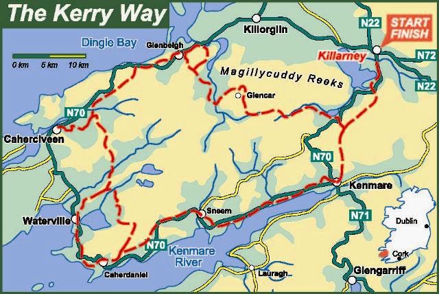
E8 Preview: Kerry Way

The shortest section of my hike turns out to be on the longest at 230 km in total. I am walking a single day on the route between Kenmare and Killarney in a single day. The two towns being the highlights, but in-between there is plenty to experience on route of a naturous nature.

This map approximates the route. It actually enters Killarney National Park further east.

So highlights. I believe whilst the route doesn't directly go over any of them it does weave through a bunch of mountains on the way so the views - I expect - will be spectacular. Towards the end of the hike I will be walking between the Torc and Mangerton Mountains which open up to Lough Leane (or Loch Léin - lake of learning) which I suspect will be spectacular, in front (on account of the Loughs) and behind (on account of Torc waterfall)!

Historically the region has it's own fair share of notable events and tradition. As I said above, the largest of the two Loughs is named Lake of Learning, this is because of the monastery on Innisfallen island. The Monastery was a key point of learning within Island in the middle ages and it is from here that a chronicle of the times was created, the Annuls of Innisfallen. Going even further back I will be going to Ross Island where copper has been mined since Pre-historic times with evidence of the Beaker People (early Bronze Age cultrue within Europe) here. Alongside the mines is Ross Castle, the ancesteral home of the O'Donoghue clan and the Brownes of Killarney. Built in the 15th Century it has it's own chequered past, being involved in wars and rebellions, and a particularly perplexing myth involving a lord sucked from his room into the lake where he waits in a palace keeping a close eye on everything that he sees.... Fish presumably. 

Tuesday, 4 February 2014

E8 Preview: Beara Way

Dear one and all.

Oh, aren't you all just so excited to be here! One will tell you those things about the Beara Way that you have come to hear and have already heard SO much about. Why don't you all calm down and stay a while as it is now my place to, so very briefly, pre-view that which you will have the pleasure of enjoying on some future day hence.

...Enough of that nonsense. Yes that is Mr B the Gentleman Rhymer. No it isn't relevant.

This is actually part one of my previews of the Irish E8.

Part 1: The Beara Way


The Beara Way is a ring of paths around the Beara Peninsula in South West Ireland. It traverses within both Cork and Kerry and was formally opened in 1996. For my walk this is the most I will see of the coast. Rugged sea cliffs rising to the central mountains of the peninsula with moorlands and woods in-between make this one section of the hike that I am looking forward to the most on the outset; this is exactly the sort of countryside I love.

The Beara way not only is part of the E8 but also it is one half of the Beara-Breifne Way. This long distance path follows and commemorates route of the march by Donal Cam O'Sullivan, Prince of Beare who after taking part in the Nine Years War with a range of other Gaelic Clans was forced to retreat north. I look forward to finding out more about the history of the area on the route which is frankly, exceedingly rich. Not only does it hold within it's bounds tales of escaping Princes but also clandestine Catholic shrines, copper mines and pre-historic ritual stones and burial tombs.

Also if I have the time I will try and go on Ireland's only cable-car, across a short stretch of the Atlantic Ocean to Dursey Island! Some might say this is a needless extension of the walk, I say, no no no.

Practically speaking I will be spending my first 2 nights and 3 days of the hike on the Beara Way, which will test me and my fitness. My first night camping is on a site near Tousist, which will test my tent. And much of the route is isolated with little in the way of shops or amenities, which will test my planning and fortitude!

I can't wait!


UPDATE--
For further info on the Beara Way have a look at this blog post by the De La Salle Scout Group; just call me Mr Excited!

Sunday, 2 February 2014

Writing the E8: The Perils of History

Aim: To write a short book on my E8 hike.
How: I will plan in advance, make notes on my progress and observations, and finish writing it within a month of returning home.
Why: For myself and to complete something that may be useful to others.

There you go. Seems so simple! Hmm, well maybe not. So far the research that I have done has only been for the Beara Way and once again I realise why I am so interested in going to Ireland. There is such a rich history there and it threatens to cause my book to expand dramatically; but largely because the stories and features I will come across are so interesting to me! For example, the Mass Rock just after Allihies is a treasure-trove that starts with a mid-17th century clandestine Catholic ceremonies held on a cold and blustery nights; it then leads past destroyed churches and repressive laws, Cromwell's invasion and the history of English/Norman involvement on the island and then on to the 5th century, when Saint Patrick et al. brought Christianity to is island.

Sigh.

So much exciting history to be contained within such a pitifully small enterprise. Oh well, never mind. :-)

Friday, 31 January 2014

E8 Preview: The Overview

Starting at Dursey Head on the 1st March and with an expected completion date of the 21st in Dublin I will be hiking across Ireland along E8 long distance hiking path.


The route will take me between 550 and 600km (information varies) along 6 of Ireland's national hiking routes. In reverse order, the Wicklow Way, the South Leinster Way (The Barrow Tow Path), the East Munster Way, the Blackwater Way (the Avondhu Way and Duhallow Way ), the Kerry Way and finally the Beara Way in west Cork. Over the next month I will try and do some research what I can expect to find on route, completing quick preview posts on each section.

The above image is taken from the Da La Salle Scout Group, who in 2012 completed the whole thing in 1-3 day stages. I am lucky enough to have a girlfriend understanding enough and a personal situation that allows me to allow me to do the whole thing in one go. I am not sure if anyone else has done it this way.

In fact the internet has only brought up a handful of people (in English) who have focussed their efforts on the E8 as a whole. One other person who I have managed to contact is Jan of e8trail.com who is currently in the process of completing the Polish sections on the E8 and has been really helpful in answering my extremely basic questions; thanks Jan!

Have you, or do you know of anyone else who has done the Irish E8? If so I would love to hear about it and get some tips!

Thanks for reading. :-)


Thursday, 30 January 2014

Shout-out! Training advice.

Hello everyone who has been pointed here by Sarah. Thanks for taking some time to look at this blog, I really appreciate it. :)

I thought I would take advantage of your interest to sound you all out for some advice. One thing that I am consistently avoiding is training. Could anyone give me some advice or encouraging words on training for this long distance hike?

Thanks. :)

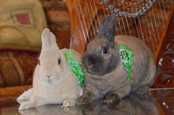
Here is a picture of some award winning Irish rabbits that I stole off the internet. Not the rabbits... Just the picture.


Monday, 27 January 2014

Thoughts on Writing

It seems daft to think that this is possible for me to do, but I am planning to write a book.

Nothing too adventurous... so to speak... but a short book or guide on my hike across Ireland on the E8. The idea being that I believe that the route is one that is worthy of information and support and that it would be an easy thing for me to write and self publish. This in turn would satisfy another need in my life at the moment that of self sufficiency.

Generating any amount of money from this project is never going to happen. It is simply a first toe-in-the-water exploration into a field that would suit my lifestyle at the moment. It would also develop my self confidence; to have completed not only a relatively strenuous hike solo and then to use the notes that I wrote on the hike to create something worth reading (even if it is for the tiniest of tiny audiences). Well that would be something worth doing. And things worth doing are things I need right now.


I plan to plan. That is, I am planning to do this by the numbers as much as possible. I will have as much of the book already worked out as I can before I actually go. Whilst on the hike I have a wonderful little notebook (pictured above) that was given to me as a gift. It contains plenty of room to scribble some thoughts along the way, but also helpful advice and inspirational countryside pencil sketches (by Wainwright) imbued with feelings of respect and the appreciation of beauty.

With notebook in hand I will seek out to create a guide. This guide will at the first be practical (because of the limitations of my writing ability), but perhaps, also include some reflections on the history and cultures of Ireland. It will be a 'how-to' but one (because of the difficulties of the route) that does not detract from the any sense of achievement that one might feel on achieving the day's goal.

Saturday, 25 January 2014

Hiking in Ireland - The plan


The E8


The E8 is a very long distance (and inspirational) hiking route across Europe. It is an exciting prospect and one that I hope to complete one day. I imagine being able to truly see the change in cultures, geography and languages at a pace that does them justice, that of someone walking. The challenge is great, over 2900 miles (4700 km) and I know of only one person who has come close to covering a large portion of it.

Starting in the green hills of Ireland you take a ferry across to the industry of northern England. Then on to Amsterdam and the flats of the Netherlands, Germany Austria (an optional section in the Czech Republic), Slovakia, Poland, Ukraine, Romania, Bulgaria and finally arriving in Turkey.

In March I will be doing the Irish section. 21 days of hiking variously staying in hotels, B&Bs and wild camping! Exciting times. If you would like to have a look at the plan clink on the link below.

THE LINK BELOW.

This is a real adventure for me. I haven't done anything like it in my life and it is truly out of my comfort zone. Right now, as the planning is all but done, I am getting as much advice as I can and sourcing what equipment I need on an extremely low budget.

And that is the real problem with the hike. The budget. It is so low that to get there from Prague I am going to have to take the bus. That's right. The bus, from Prague to London and then again from London to Dublin. Finally once in Dublin I will take another bus from Dublin to my first hostel. That in itself feels like it will be an achievement to survive, let alone doing a 500km hike afterwards; I wonder if my muscles will have fully atrophied by that point? I hope not!

Anyway. The question that I leave you with is this. Do you have any advice for a novice long distance walker who is about to embark on his first blister-inducing endeavour?